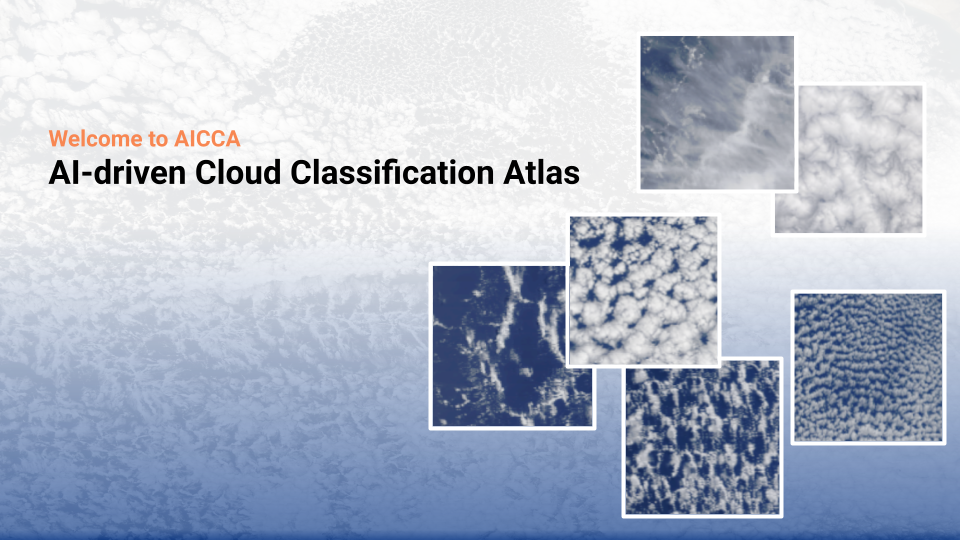
AICCA
Democratizing large MODIS data accessible, discoverable, and usable
AICCA has explanatory power
-- capturing regionally unique cloud classes
data-driven cloud atlas free from artificial assumptions
-- providing rich but tractable information for global cloud analysis

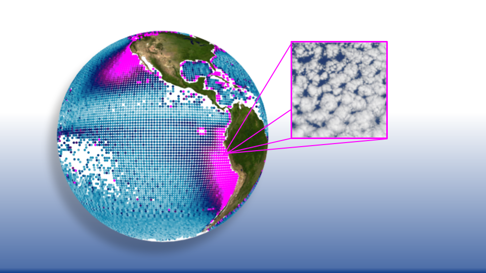
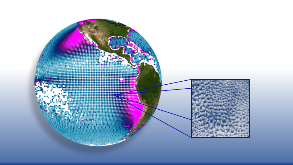
Strong geographical distribution
capturing unique spatial patterns
What is AICCA?
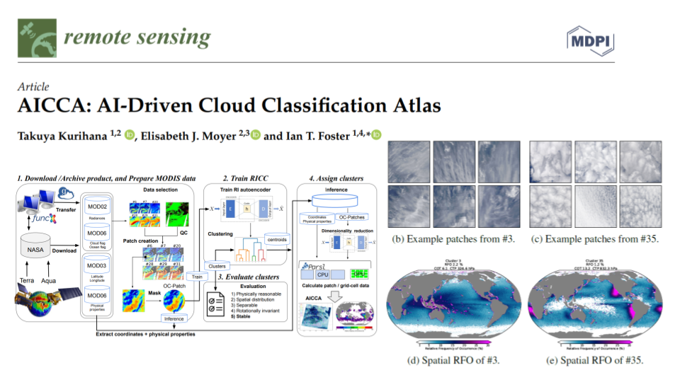
The AI-driven cloud classification atlas AICCA is an unsupervised machine learning-based new cloud dataset that clusters 22 years of ocean satellite images from the Moderate Resolution Imaging Spectroradiometer (MODIS) on NASA's Aqua and Terra instruments—198 million patches, each roughly 100 km x 100 km (128 x 128 pixels)—into 42 AI-generated cloud classes. AICCA translates 801 TB of satellite images into 54.2 GB of class labels and cloud top and optical properties, a reduction by a factor of 15,000.
The 42 AICCA classes produce meaningful spatiotemporal and physical distinctions and capture a greater variety of cloud types than do the nine International Satellite Cloud Climatology Project (ISCCP) categories—for example, multiple textures in the stratocumulus decks along the West coasts of North and South America. The AI-generated dataset enables data-driven diagnosis of patterns of cloud organization, provides insight into cloud evolution on timescales of hours to decades, and helps democratize climate research by facilitating access to core data.
Featured Publications
AICCA: AI-Driven Cloud Classification Atlas
Clouds play an important role in the Earth's energy budget, and their behavior is one of the largest uncertainties in future climate projections. ... Satellite observations should help in understanding cloud responses, but decades and petabytes of multispectral cloud imagery have to date received only limited use. This study describes a new analysis approach that reduces the dimensionality of satellite cloud observations by grouping them via a novel automated, unsupervised cloud classification technique based on a convolutional autoencoder, an artificial intelligence (AI) method good at identifying patterns in spatial data. Our technique combines a rotation-invariant autoencoder and hierarchical agglomerative clustering to generate cloud clusters that capture meaningful distinctions among cloud textures, using only raw multispectral imagery as input. Cloud classes are therefore defined based on spectral properties and spatial textures without reliance on location, time/season, derived physical properties, or pre-designated class definitions. We use this approach to generate a unique new cloud dataset, the AI-driven cloud classification atlas (AICCA), which clusters 22 years of ocean images from the Moderate Resolution Imaging Spectroradiometer (MODIS) on NASA’s Aqua and Terra instruments—198 million patches, each roughly 100 km × 100 km (128 × 128 pixels)—into 42 AI-generated cloud classes, a number determined via a newly-developed stability protocol that we use to maximize richness of information while ensuring stable groupings of patches. AICCA thereby translates 801 TB of satellite images into 54.2 GB of class labels and cloud top and optical properties, a reduction by a factor of 15,000. The 42 AICCA classes produce meaningful spatio-temporal and physical distinctions and capture a greater variety of cloud types than do the nine International Satellite Cloud Climatology Project (ISCCP) categories—for example, multiple textures in the stratocumulus decks along the West coasts of North and South America. We conclude that our methodology has explanatory power, capturing regionally unique cloud classes and providing rich but tractable information for global analysis. AICCA delivers the information from multi-spectral images in a compact form, enables data-driven diagnosis of patterns of cloud organization, provides insight into cloud evolution on timescales of hours to decades, and helps democratize climate research by facilitating access to core data.
MDPI Remote Sensing 2022, 14(22), 5690; DOI:10.3390/rs14225690
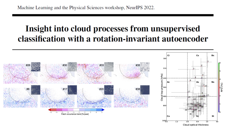
Insight into cloud processes from unsupervised classification with a rotationally invariant autoencoder
Clouds play a critical role in the Earth's energy budget and their potential changes are one of the largest uncertainties in future climate projections. ... However, the use of satellite observations to understand cloud feedbacks in a warming climate has been hampered by the simplicity of existing cloud classification schemes, which are based on single-pixel cloud properties rather than utilizing spatial structures and textures. Recent advances in computer vision enable the grouping of different patterns of images without using human-predefined labels, providing a novel means of automated cloud classification. This unsupervised learning approach allows discovery of unknown climate-relevant cloud patterns, and the automated processing of large datasets. We describe here the use of such methods to generate a new AI-driven Cloud Classification Atlas (AICCA), which leverages 22 years and 800 terabytes of MODIS satellite observations over the global ocean. We use a rotation-invariant cloud clustering (RICC) method to classify those observations into 42 AI-generated cloud class labels at ~100 km spatial resolution. As a case study, we use AICCA to examine a recent finding of decreasing cloudiness in a critical part of the subtropical stratocumulus deck, and show that the change is accompanied by strong trends in cloud classes.
The 36th conference on NeurIPS Machine Learning and the Physical Sciences workshop; DOI:10.48550/arXiv.2211.00860
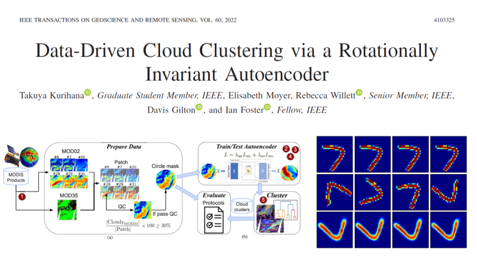
Data-Driven Cloud Clustering via a Rotationally Invariant Autoencoder
Advanced satellite-borne remote sensing instruments produce high-resolution multispectral data for much of the globe at a daily cadence. ... These datasets open up the possibility of improved understanding of cloud dynamics and feedback, which remain the biggest source of uncertainty in global climate model projections. As a step toward answering these questions, we describe an automated rotation-invariant cloud clustering (RICC) method that leverages deep learning autoencoder technology to organize cloud imagery within large datasets in an unsupervised fashion, free from assumptions about predefined classes. We describe both the design and implementation of this method and its evaluation, which uses a sequence of testing protocols to determine whether the resulting clusters: 1) are physically reasonable (i.e., embody scientifically relevant distinctions); 2) capture information on spatial distributions, such as textures; 3) are cohesive and separable in latent space; and 4) are rotationally invariant (i.e., insensitive to the orientation of an image). Results obtained when these evaluation protocols are applied to RICC outputs suggest that the resultant novel cloud clusters capture meaningful aspects of cloud physics, are appropriately spatially coherent, and are invariant to orientations of input images. Our results support the possibility of using an unsupervised data-driven approach for automated clustering and pattern discovery in cloud imagery.
IEEE Transactions on Geoscience and Remote Sensing, vol. 60, pp. 1-25, 2022, Art no. 4103325; DOI:10.1109/TGRS.2021.3098008
Notebook
We provide an example Jupyter notebook to use AICCA dataset for cloud analysis. We offer a sample AICCA dataset to play with our dataset in Download AICCA, while the full disk of AICCA data are available upon request until May 1, 2023, on which date all data will be made available without restriction.
Acknowledgements
Our work is made possible by much-appreciated support from the National Science Foundation, Department of Energy, University of Chicago Data Science Institute, the Argonne Leadership Computing Facility, University of Chicago's Research Computing Center and other sources. AICCA is a product developing by Clouds project with the team from Globus labs, The Center for Robust Decision-making on Climate and Energy Policy (RDCEP), and The UChicago Data Science Institute.